
NewsWPLG Local 10 – Main FeedAugust 25, 2026Miami-Dade County
National Hurricane Center monitors Invest 96L for potential development
Photo: WPLG Local 10 – Main Feed
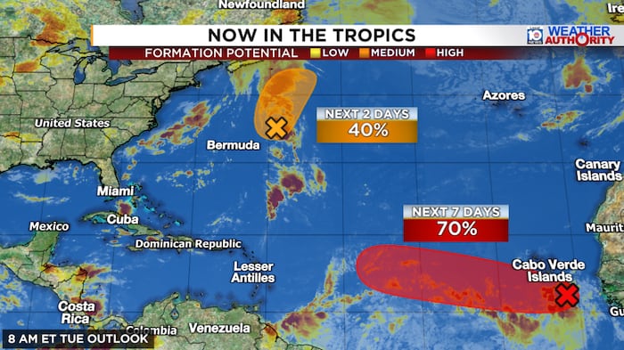
The National Hurricane Center is tracking a weather disturbance designated Invest 96L, which has a high probability of developing into a named storm in the coming days. Forecasters are currently uncertain if the system will survive wind shear conditions this weekend or if it will strengthen as it moves toward the western Atlantic next week.
Read the full story at WPLG Local 10 – Main FeedWhy It Matters
Residents in the Caribbean and along the U.S. East Coast should monitor this system as it is in the early stages of development and its future path and intensity remain highly uncertain.
Key Facts
- The National Hurricane Center has raised the probability of development for Invest 96L to 'high' based on satellite data showing improved circulation.
- Invest 96L is currently facing significant wind shear in the central Atlantic, which may hinder its development this weekend.
- Forecast models are divided: some predict rapid intensification into a hurricane, while others suggest the system will remain weak or dissipate.
- If 96L survives the weekend, it may encounter conditions favorable for further strengthening in the western Atlantic next week.
- Invest 95L, located northeast of Bermuda, is expected to dissipate by Thursday and poses no threat to land.
- The Google DeepMind model currently shows low probability of development for 96L this week.
- The European model suggests a path that could lead to a second stage of development near the U.S. East Coast next week.
Who's Mentioned
otherInvest 96L“A weather disturbance currently being monitored for potential development.”OrganizationNational Hurricane Center“The agency responsible for tracking and forecasting tropical weather systems.”otherInvest 95L“A separate, weakening weather system near Bermuda.”OrganizationGoogle DeepMind“Developer of an AI-based weather forecasting model.”