
NewsPasadena NowNovember 10, 2026Los Angeles County
Pasadena Closes Streets for CicLAvia Event on Sunday, Nov. 15
Photo: Pasadena Now
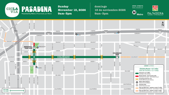
Pasadena will close 2.7 miles of Colorado Boulevard and Raymond Avenue to vehicles on Sunday, Nov. 15, for a free open-streets CicLAvia event. Road closures and parking bans will take effect starting at 4 a.m. and last until approximately 5 p.m., while the event itself runs from 9 a.m. to 3 p.m.
Read the full story at Pasadena NowWhy It Matters
Drivers will experience extended road closures and parking prohibitions along major corridors including Colorado Boulevard and Raymond Avenue from 4 a.m. to 5 p.m., while residents on the route may qualify for up to $20 in parking reimbursement.
Key Facts
- Pasadena is closing 2.7 miles of Colorado Boulevard and Raymond Avenue to cars on Sunday, Nov. 15, for a free CicLAvia event.
- The open-streets event runs from 9 a.m. to 3 p.m., but road closures will last from 7 a.m. to approximately 5 p.m.
- Parking is prohibited on the main route and Slow Streets from 4 a.m. to 5 p.m. on Nov. 15, and towing will be enforced.
- Residents and businesses living directly on the route may qualify for up to $20 in parking expense reimbursements with receipts due within 30 days.
- Drivers will be able to cross the route at six designated intersections shown on the organizer's route map.
- Two milelong temporary bicycle connections called Slow Streets will be added along Walnut Avenue and Colorado Boulevard.
- Two activity hubs located at 145 N. Raymond Ave. and 1778 E. Colorado Blvd. will provide restrooms, water refills, basic bike repairs, and first aid.
- Electric scooters and motorized skateboards are prohibited, though mobility devices for people with disabilities are allowed.
- This marks Pasadena's first CicLAvia event since May 2015.
Who's Mentioned
OrganizationCicLAvia“Nonprofit organization co-hosting the open-streets event”locationPlayhouse Village“Neighborhood the route passes through”locationPacific Alley“Boundary for the Raymond Avenue route”locationWalnut Avenue“Location of temporary Slow Streets connection”locationRosemont Avenue“Mentioned in relation to Slow Streets route”locationOrange Grove Boulevard“Mentioned in relation to Slow Streets route”locationRose Bowl“Landmark near the Slow Streets connection”OrganizationMetro“Transit agency with nearby rail stations”locationLamanda Park“Mentioned in relation to Slow Streets route”locationRaymond Avenue“Main route street for the event”locationColorado Boulevard“Main route street for the event”locationPasadena“City hosting the CicLAvia event”locationOld Pasadena“Neighborhood the route passes through”locationAllen Avenue“Boundary for the Colorado Boulevard route”locationLos Angeles“City where the nonprofit began holding open-streets events”locationSan Gabriel Boulevard“Mentioned in relation to Slow Streets route”locationEast Dayton Street“Boundary for the Raymond Avenue route”